Updates
Live interaction with BASC Team & Members - 2nd May 2020

Sunday, November 27, 2011

(PART 1 is here)
Sleep was hard to come by during the night as the wind continued to howl. A large part of the night was spent just awaiting the dawn. I was the first one up in the camp. I hastily got ready and decided to head off for a morning stroll along the stream.

Morning view from the campsite
By now the sun had risen but still wasn’t visible due to the hills in the east. The banks of such streams are rather fertile. These are the only spots that tree growth can be observed at such altitudes in the ghats. I proceeded to sit by the stream take a  few shots of the stream and frogs I observed hopping nearby.

A frog by the Bandajje stream
On heading back to the campsite I had some cup noodles and packed up. It was now time to proceed to our next destination, Ballarayana Durga fort. There is no genuine path to the fort. Most of route involved navigating our way through the tall montane grass over a series of undulating hills. After completing a series of these we could finally catch a glimpse of the ruined fort through our binoculars. A rather straight forward path along the ridge of a few hills became apparent and the excitement was evident among the group.
Far away, on the path leading to the fort, we suddenly glimpsed movement. There were excited cries among the group of the possibility that we may have spotted an elephant. On closer inspection the animal appeared bovine. We quickly assumed it to be a bison (gaur), a terrific find none-the-less. I was still rather sceptical though and decided to put my 300mm of zoom to use and take a snap. On observing the image on the LCD we realised it was just a buffalo and chuckled at our naivety.
At this point Phrabhakar began moving a little ahead of the group and assumed the lead. I was at the back and had lost sight of him till I saw our brave pioneer rapidly scampering backward while simultaneously taking photographs. A moment later we saw the cause for his panic, he was being chased by a rather angry buffalo.

Thats the one!
The group tried moving forward as one unit and tossing stones at the bovine, but sadly to no avail. It seemed to enrage the buffalo bull further and made us scamper up a nearby hill. Any further and we’d be forced off the cliff.
If you know me or have read my blog before I’m sure you saw that coming. This is the third trek I’m getting into bovine trouble. Anyways…….

The group being chased up the hill. Photo Courtesy: Siddharth
We thought of approaching the fort from an alternate route through the valley. This plan was soon scrapped on sighting more buffaloes grazing on the opposite hill.
Some of the guys were panic stricken by the number of buffaloes around us while others saw the funny side of it. Battle lines had been drawn, strategies meticulously planned and troops summoned….this was war!!
We observed that it was just a single individual and not an entire herd that was making life difficult for us. Eventually we decided to bide our time till the buffalo moved away from the path and then make a run for it. And run for it we did! Being towards the tail of the group I was forced to push myself hard. I sprinted and refused to look back till I was a thousand meters from the war zone.
From here on the path to the fort was a rather smooth one. We did see a few more buffaloes in the distance causing a little bit of panic in our ranks. But none of these seemed to take any interest in us. We quickly ascended to the fort with our cameras vigorously clicking away. We had won this battle and it was now time to celebrate with refreshments. 
A panoramic view from the fort.
Not much is known about Ballarayana Durga. After a good bit of googling I’ve still been unsuccessful in finding information on the fort and would love it if you could provide me with some.  One thing is certain though, the views from here are breathtaking. I’ll let the pictures do the talking.

A view from the fort. HDR
As per the plan, we were to start our descent from here on. Our first attempt to do so saw us reach a dead end. In the distance we could see the rain clouds brewing and pouring on distant valleys. As be backtracked we happened to startle a rather large dark rat snake who decided to quickly slither away from us. On walking a bit further we could see something that resembled a jeep track in the distance, down in the valley. There appeared no visible way to get to the track though. Johan decided to lead the way. We followed him, along cattle tracks, through prickly grass down into a valley. Along the way, we managed to startle some more wildlife, a hare on this occasion. After an hour or so we hit a trail that we assumed would take us to the jeep track.
The open grasslands were now only a distant memory as be began traversing through dense forest again.  We all moved fast as we were hungry and were looking  for a place to have lunch away from the festering leeches. We soon hit the jeep track that further led to a house that I assume belonged to a local priest. With civilization just a stone’s throw away, we decided to break for lunch at the house.

A close-up of one of the many streams flowing through the forest.
It was at this point it dawned upon me that till that point we hadn’t seen a single other person apart from our group mates for the duration of two whole days.
Form here it was a rather straight path through fields then villages. Before we knew it we managed to get a jeep to drop us to Sunkasale village. Our first order of business here was a nice cup of tea, my first in two days. Next, we boarded a bus to the temple town of Hornadu, where we were catch a bus to Bangalore later that night.
On getting to Hornadu we freshened up and decided to seek blessings at TheAnnapoorneshwari  temple. This temple makes up almost half of the town, which just about tells you it’s prominence among the people.  The temple also offers an evening meal to its devotees. Kind of like a South Indian version of the Punjabi Langar.
With our bodies fresh and our stomach satiated we boarded our bus back to Bangalore.

Route:
To:  Bangalore>Dharmasthala>Ujire>Mundajje
Fro: Sultanpet>Sunkasale>Hornadu> Bangalore
GPS track compiled by Naveen.


Event Name: Trek to Bandaje Arbbi falls and Ballalarayana Durga fort: BABD/6_26-27-Nov-2011
Original Writeup by: Aniruddha
Event organized by: Girish

Image Galleries: Raghavendra, Siddharth, Aniruddha, Brijesh, Girish, Johan, Naveen, Prabhakar

Saturday, November 26, 2011

I sat there, all alone near the peak of a nameless hill. The sun began to recede slowly, the light began to dim. The beauty of the dusk had once again set upon the Ghats. In the distance, I glanced upon the Arabian sea.  I enjoyed every moment up there, the rustle of the shola grass, the screaming wind, the sudden bouts of mist and thought to myself, ‘this is life’.

Sunset.
I sat there, alone, thinking how fortunate I was to experience such a feeling again. It was just three months ago that I had a crazy bicycle crash on tour. I couldn’t walk for a month after and the effects lingered on till about a few days before the trek.
The trek I am talking about was one to Bandajje Arbi falls and Ballarayana Durga fort. It was organized by the Bangalore Ascenders group.  This route is located in the Charmadi Ghats area in the Dakshina Kanada district of Karnataka.
I set out from home on the night on Friday night, the 25th of November. Needless to say I had butterflies in my stomach. Majestic bus stand, Bangalore, platform 14 was the spot designated to meet the rest of the travelling party. The group consisted of 12 guys, all rather experienced at such outings.  After a hasty round of introductions we were all seated in the bus. We arrived at our destination, a town called Dharmasthala, before the break of dawn. We had to wait for sunrise before we could get ourselves some breakfast and a ride to the base village of our trek, Mundajje. A little after daybreak we hired 2 gypsies and were off.
After navigating some non-existent roads for an hour we finally reached Mundajje. And so here began our trek. We quickly moved through the local fields and into the forest. The lack of moisture in the forest bed made sure the leech menace was minimal. The terrain was undulating till the first stream crossing.
The stream crossing was slightly tricky. The lucky ones only got their feet wet unlike others who happened to drop their belongings.  After this point the route got steeper, the sun rose higher and the humidity began to sink in.  Progress was slow and frequent breaks became necessary. Every gust of wind was greeted with smiles from the travellers and a cacophony of noises from the drying forest.

Johan standing under a particularly large fig tree.
After about 4 hours in the forest we finally hit the high altitude grasslands. These grasses called shola grasses are endemic to the south of the Western Ghats. Reaching the grasslands always brings renewed energy to a group on any trek. The wind blows freely here, the weather is cool and one can view the most beautiful vistas in all directions. After the monotony of the forest the grasslands are often a sight for sore eyes.

Bandajje Arbi Waterfall in the distance.
We were informed by our leader, Girish, that the Bandajje Arbi waterfalls were barely a few kilometres away. Soon the falls became visible in the distance and got the shutterbugs amongst us excited.  Our proposed campsite was in the direction of the falls so we continued to head in that direction. Halfway to the falls we decided to stop for lunch. Signs of the presence of wild animals in the area were evident. The ground was littered with elephant and bison dung.
We moved forward and reached the stream that would flow to culminate at the falls. Girish and a few others left to identify a campsite. I just decided to loiter around by the stream and click a few photographs. After an hour or so and a lot of gaffes the camp, …umm more like two flimsy sheets of tarpaulin were set up. It was now time for the restless among us to explore the area.

Bandajje stream flowing by our campsite.

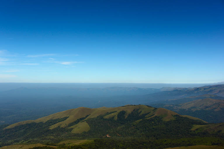
Johan and Dan decided to ascend to the peak of this hill which looked to be the tallest in the vicinity. I decided to join them, hoping I’d get a few good clicks up top. What I got though was way more than any of us bargained for. The other side of this hill was more of a steep rock face. It provided us a panoramic view of the entire area. In the distance I glanced upon Ballarayana Durga fort, our destination for the next day.  The wind here was crazy and refused to let us stand still for more than a few seconds. After a few superman poses we decided to head down. At this point it was about 5pm. I decided to let the two of them carry on and wait half-way up this hill for the sunset in the west. Though the grand sunset I envisioned never occurred the time spent alone on that hillside was simply magical.

  View from the hilltop.
As darkness began to set in I started moving towards base-camp.  As the entire team began to gather we had only one thing on our mind, dinner.  A three course meal in the middle of nowhere is a godsend. We started with soup; some awful MTR precooked rice and rotis and topped it off with canned Gulab Jamun.
The night was rather rough with constant gusts of wind sending shivers through our bodies. The fact that our tarpaulin structure collapsed in the middle of the night did not help our cause of getting some sleep.

PART 2
Event Name: Trek to Bandaje Arbbi falls and Ballalarayana Durga fort: BABD/6_26-27-Nov-2011
Original Writeup by: Aniruddha
Event organized by: Girish
Image Galleries: Raghavendra, Siddharth, Aniruddha, Brijesh, Girish, Johan, Naveen, Prabhakar

Monday, November 21, 2011

Time for me to share my experience about the most beautiful historical place in Karnataka, Hampi,,, machi !!!!
Many of my freinds visited this place and they used to share their experience with unusual words ohh its sooper, ahh its surprising with the architects around any many other sounds,, ohh lala !!!!
After seeing the images of Hampi & hearing the history behind was planning to go to Hampi & then I heard  abt the group called BASC which organizes diff type of trips at very reasonable packages.
We a group of 18 ppl sat into mini bus on 19/Nov started our journey from Bangalore , we stopped our vehicle at Kamat hotel for dinner. After 5 hrs we were in Hampi city. It was around 7-8hrs journey from Bangalore 360kms.
Every 1 were new to me except Ramya(my colleague), within very few hrs we all became 1 group & moved further, sharing our personal & official life Histories. Every1 had a story of their own :P ,
Below are the list of people,
  1. Mohan(Me :P ),
  2. Ramya( artistic photographer),
  3. Abha Kumari ( food expert ),
  4. Krutika ( looks like silent creature at first sight ),
  5. Deepak ( Nikon expert ),
  6. Rajesh ( I phone master/multi tasker ),
  7. Jinu ( Trekking master ),
  8. Karthik ( Seemed lil reserved at first then he was casual ),
  9. Girish ( Exited photographer, funda GURU ),
  10. Mitesh ( Sensitive darling, he wont speak until you start the conversation ),
  11. Srinivas ramanna ( Busy bee, you cant find him in the group he will be busy alone ),
  12. Pradeep ( My room mate, chocolate boy ) he had lot of chocos in his bag,
  13. Priya alias Castle mountain ( Busy when group is free & free when group is busy ),
  14. Gururaj ( New owner of Nikon ),
  15. Vijayalakshmi ( She has comments for all photos, light is not gud ya :P ),
  16. I forgot uncle’s name, he was very energetic n enthu,
  17. 2 nd name which I forgot, silent guy who didn’t spk first whole day n he said gud mrng on 2nd day & ashte nothing after that,
  18. Last but not the least Mr. Yadunandana – Organiser for hampi trip, perfect gentleman managed group with his 5-10 mins time limit !!!
Short summary abt Hampi !!!
Hampi is a 700 year old city built by Hakka and Bukka in the year 1336 on the banks of river Tungabhadra. It’s the capital city of Vijayanagar empire. They built the city under the guidance of Saint from Sringeri mutt called Vidyaranya. The city Hampi was built during the days of Mohammedan attacks. The palace was very much apt at that time. It was at the banks of river Tungabhadra and it’s full of rocky Hills. It’s really difficult to any one to cross those rocks to conquerthe empire at that time.
Spread over an area more than 25 square kilometers (10 square miles), Hampi ruins is packed with giant temples, palaces, market streets, aquatic structures , fortifications and an abundance of other ancient monuments.
The Vijayanagar Empire was ruled by the likes of HakkaBukka I and II , Virupaksha Raya, Krishnadeva Raya, Achyuta Raya, etc. It was under Krishnadeva Raya that Vijaynagar empire found its most prosperous days.
Hampi has a number of festivals throughout the year – both cultural and religious. The most celebrated festival is the Vijaya Utsav, known as Hampi Festival, held for three days during November. This is a cultural carnival attracting many tourists, showcasing special puppetry shows, music and dance followed by fireworks and a procession culminating the end of the festival.

Travel within city
Travelling around Hampi can be fun, as the region is steeped in history and travelling around the place can be quite interesting. You can move around Hampi through bikes, motorcycles, cars or even boats. These are the various types of internal travel options present in the ancient capital of Hampi. There are no night fares for any mode of transport.

Taxi
Renting a car can be more costly and can cost you around Rs 800-1000. You can travel to the guesthouses that are located across the river through boats for prices ranging around Rs 10 to 15.

Auto Rickshaw
You can also opt for rickshaws, in case you want to beat the heat. Rickshaw rates are fixed and slightly negotiable, so make sure that you get the best out of the bargain. The charges are normally around Rs 400-500 per day. You can also hire a guide to accompany you long the trip and this may cost you extra.
Rented Bicycle You can rent a bicycle in Hampi in order to travel up and down the hill.

Rented Motorcycle
You can also rent out a motorcycle while on a trip in Hampi as this mode of travel can give you more freedom. You can rent out 100cc and 150cc vehicles for charges of around 200 INR to 250 INR per day. This may be slightly more expensive, but you can ride through the expanse of Hampi and take in the sheer magic of the place. 

Started from Virupaksha temple

Virupaksha Temple !!! Virupaksha Temple !!!
Virupaksha temple is the oldest and the principal temple in Hampi.This temple is located on the south bank of the river Tungabadra, It believed that this temple has been functioning uninterruptedly ever since its inception in the 7th century AD.That makes this one of the oldest functioning temples in India.
Balakrishna Temple !!

Balakrishna temple Balakrishna Temple !!
Inside Balakrishna Temple !!
Balakrishna temple 1 Temple of Balakrishna temple !!

Krishnadevaraya built this temple in 1513 A.D. to commemorate his victory over Prataparudra Gajapati, the ruler of Orissa. During the battle he seized an image of child Krishna and brought it to Vijayanagara as war trophy. He then built this temple to consecrate the image. An inscription describing the conquest and the consecration of this temple on 16 February 1515 by Krishnadevaraya is found on a slab in front of this temple. Built in the centre of a courtyard, the temple possesses a sanctum, an antechamber, an ardha mantapa, a circumambulatory passage, a pillared hall with three entrances and an open pillared mantapa, in addition to a number of other shrines for the attendant deities. The sanctum is at present empty. The image of Balakrishna showing him as a child holding butter in the right hand is now resting in the Government Museum at Madras. 

Bazaar opp to Balakrishna Temple !! 

Bazaar opp to Balakrishna Temple Bazaar opp to Balakrishna Temple !!
Lakshmi Narasimha Temple !!

Lakshmi Narasimha Temple Lakshmi Narasimha Temple !!
This is the largest statue in Hampi. Narasimha is sitting on the coil of a giant seven-headed snake called Sesha. The heads of the snake acts as the hood above his head. The god sits in a cross-legged Yoga position with a belt supporting the knees.The original statue contained the image of goddess Lakshmi, consort of the god, sitting on his lap. But this statue has been damaged seriously during the raid leading to the fall of Vijayanagara. Even the damaged portion of such a large statue of Lakshmi carved on his lap is missing. But the goddess’s hand is visible resting on his back in embracing posture. If you get a chance to go inside this enclosure, it is possible to see the hand of the goddess. Even the nails & the rings on her fingers are so perfectly executed. 

Badavi Linga !! 

Badavi Linga Badavi Linga !!
 
This is the largest monolithic Linga in Hampi. Located next to the Narasimha statue the Linga is housed inside a chamber with an opening in the front. One legend has it that this idol was originally carried around by a poor woman and it accidentally fell into the canal. So when the distraught woman prayed to the lord Shiva, the idol grew to the height it is today.

Queens Bath !!! 

Queen's bath Queens Bath !!!
 
In Hampi, the Queen’s Bath is part of the Royal Enclosure. This was constructed during the Vijaynagar Empire any time from 1336 to 1565. This is a enclosed space, consisting of a complex of changing rooms and a bath. At present only the bath is extant. 

Temple view from Queens bath complex !! 

View from Queen bath complex
View from Queens bath complex !!
Mahanavami Dhibba !!!
Mahanavami Dhibba Mahanavami Dhibba !!!
The massive stone basement called Mahanavami Dibba, also called as Dasara Dibba played a prominent part during the celebrations of the nine-day Navaratri festival.The Dibba is about 12 metres high up to the floor of the topmost platform. On the west side are the steps. It was from this side that the king ascended the platform during the festivities connected with the Dasara. On the east side is a small chamber projecting from the platform. Access to the chamber is by means of two flights of steps on the north and south located on the floor of the platform itself. The walls of this chamber contain many friezes and panels including figures of animals and clowns.

Bahamani Mosque !!! 

Bahamani Mosque Bahamani Mosque !!!
Under ground Shiva Temple !!
Temple inside Under ground Shiva temple Temple inside Under ground Shiva temple !!!
Pillars inside Under ground Shiva temple
Pillars inside Under ground Shiva temple !!

This temple dedicated for Lord Siva was built many meters below the ground level. For this reason, almost all the time the sanctum and the core parts of the temple are under water, restricting entry to the inner areas. A water cannel system too is visible around the main temple. But this canal is dry and you can walk down to a point from where it’s impossible to go further. There is a small temple for Siva’s consort too near the mail shrine. The Kalyanamantapa (ceremonial marriage hall) is great a structure. It has been believed that this is one of the oldest temples in Hampi.

Our first day ends here on Malyavanta Hill with beautiful sunset view !!! 

Sun set manyavata hill Malyavanta Hill !!
 
First of all it is one of the few hilltops in Hampi where you can reach by a vehicle. That’s welcome news for those of you find it difficult to hike, despite a desire, to a Hampi hilltop.

Sunset from Malyavanta Hill !!! 

Sunset View from Malyavanta HillSunset View from Malyavanta Hill !! 
Ran to rooms, get re freshed was thinking of good, nice, calm place for dinner then thought about Mango tree restaurant, This is a very popular restaurant in Hampi, especially among the backpackers. The popularity is more so because of the settings. The dining area is essentially a terraced slop overlooking the river Thungabhadra. You need to sit on the matted floor cross-legged, in the typical Indian way, with the low table in front of you. The last row facing the river is often more popular.
Returned to rooms n slept off early as our Organizer Mr Yadu instructed to woke up early in the mrng to reach Mathanga parvatha to see Beautiful Sunrise !!! 

Mathanga parvatha Sun rise Sunrise, Mathanga Parvatha !!
 
We started our walk early in the morning at 5.40 am to watch beautiful sunrise. The climb can be little difficult as the path is slant & rocky, but is rewarding. The tallest hill in Hampi and has a 360 degree view. There is the charming river to north flowing amidst neatly arranged boulders, to the south is Virupaksha temple standing tall. 
Sunrise view Sunrise view !!
 
We came back to rooms,  had break fast & started our 2nd day from Achyutharaya Temple
Achyutharaya Temple Entrance point of Achyutharaya Temple !!
 
This temple is an example of Vijayanagara style temple architecture in its most advanced form than any other temples in Hampi, Resonating the imposing architectural style of Vijayanagara, Achyutraya Raya’s temple was built 500 years ago. Its foundation was laid by an officer in Achyuta Raya’s court. Hence the temple was named after him. It exemplifies the most advanced form of the temple built in Hampi. It was the last contribution of the Vijaynagara Empire before it declined. The temple is dedicated to the heavenly deity Tiruvengalanatha, a form of Lord Shiva.

Achyutharaya Temple view from Mathanga Parvatha !!! 

Aerial veiw of Achyutharaya temple from Mathanga parvatha Achyutharaya Temple Aerial view from Mathanga Parvatha !!
 
Tunga River view from Yantrodharaka Temple !! 

Thunga river Tunga River !!
 
Purandara Mantapa !! 

Purandara Mantapa Purandaradasa Temple !!
 
This is a small open pillared pavilion with whitewashed top dedicated to the legendary poet Purandaradasa who lived in Hampi. The pavilion is located at the river shore near Vittala Temple. This is one of the areas at Hampi where people perform religious rituals. The pavilion is almost at the edge of the river that during monsoon the river water touches the platform or even submerges it.

Vittala Temple,
Vittala Temple is the most extravagant architectural showpiece of Hampi. The temple was originally built in the 15th century AD. The highlight of Vittala temple is its impressive pillared halls and the stone chariot. The halls are carved with an overwhelming array of sculptures on the giant granite pillars. The stone chariot located inside the campus is almost an iconic structure of Hampi.

Vittala Temple Entrance, 

Vittala temple entrance Vittala temple entrance !!
Stone chariot inside Vittala complex !!

Stone ChariotStone Chariot !!! 
It was originally a shrine of Garuda, Lord Vishnu’s Vehicle. The stone chariot is not a monolith. It’s actually carved from many giant granite blocks. The joints are neatly hidden with help of the carvings giving it a monolithic feel. The chariot is built on a rectangular platform and though now the giant stone wheels seem to rest on the platform it’s believed that these wheels could rotate on its axis.
Temple inside Vittala complex !! 

Temple inside Vittala Complex Temple inside Vittala Complex !!!
 
There is a museum too which says the history of hampi, its called Kamalapur museum.
Next destination after museum was Lotus Mahal.

Lotus Mahal – This was a socializing area for the women folks in the royal family. 

Lotus Mahal Lotus Mahal !!
This is a two storied structure with an open base floor the sidewalls are having tall arched windows. The upper floors have balconies with arched windows. Hook like structures are made on to the wall close to the windows to hang curtain. The arches of the ground floor are recessed and ornate. The decorations and architecture is a curious mix of Hindu and Islamic styles. Lotus Mahal’s Islamic style arches and the Hindu style multiplayer roof and base structure are often quoted for the ingenuity of the Vijayanagara artisans.

Lotus Mahall 1 Lotus Mahal !!
Elephant Stables !!

Elephant Stables Elephant Stables !!
One among the few least destroyed structures in Hampi, Elephant stable is a major tourist attraction. This long building with a row of domed chambers was used to ‘park’ the royal elephants. There are 11 domed tall chambers; some of them are inter- connected. 

The center one is specially decorated and big.

The center Dome The center Dome !!
Last but not the least, Jain temple for Sunset shoot !!

Jain temple at sunset time Jain temple at sunset time!!
one more sunset pic to finish my blog !!!

Sunset at Jain temple Sunset at Jain temple !!!
More details abt BASC - http://www.bangaloreascenders.org/
Details abt the places were reffered from these sites
  1. http://hampi.in/,
  2. http://en.wikipedia.org/wiki/Hampi
  3. http://hampi.in/distance-to-hampi - this link helps to reach Hampi from various towns and cities in India.
So finally we went back to rooms, packed our luggage, sat in bus reached back b’lore on 21/11/2012 at 3.45 Am .

Original Writeup by:  Mohan Rajendra
Visit our Group @ CLICK HERE
Writeup and embedded pictures by: Mohan Rajendra
Event organized by: Yadunandana
Image Gallery:
Yadunandana , Jinu John , Girish Motwani , Deepak , Gururaj , Krutika , Mohan

Saturday, November 19, 2011

I’ve been wanting to do the Mullyangiri – Bababudangiri trek since I heard about this scenic route. I had initially planned to do this in mid-late November with some friends. However, as best laid plans go, this one kind of unravelled as the date drew near. However, when I learned that Bangalore Ascenders would be also attempting the trail (with the added incentive of trekking all the way to Kemmangundi), I quickly signed up for the trek. The weekend before the trek was spent in getting the necessary supplies (food, sleeping mats etc.) as I didn’t want to leave anything to the last minute.
The View from Mullyangiri                                                                                      The View from Mullyangiri

Day 0 – Leaving Bangalore

We had planned to leave on Friday night and reach Chikmaglur by early morning on Saturday. By Wednesday we had all received details on the pick-up points. As planned I reached my pickup spot at Domlur at about 10:15 in the night. I met up with one of the participants, Omendra there. We spent quite some time waiting there as the Tempo Traveler was delayed. At long last, the much awaited TT arrived and we got in. We started moving to the next pick up point near Majestic and picked up the tents along the way. Finally the rest of the team boarded at Majestic and we started on what would prove to be an adventure of epic proportions.


Day 1- Of Tall Mountains, Dark Caves, abandoned towers and scary winds

We awoke on Saturday to find ourselves at Chikmagalur. After freshening up at the bus stand, we then went on to have a sumptuous breakfast and pack some Pulav for lunch. After Breakfast we boarded the TT and went on to the start of the trail. Since the TT could go to the camping site, we just needed to take some snacks and water along. Once again the lightweight daypack that I bought turned out to be quite handy. Pretty soon we had all picked up our day packs and were ready. The TT left for the camp site and we were ready to start the trek.
Starting the Trek
First we had a quick round of introductions. There were 13 of us in all: Ranjan, Muthukumar, Kiran, me, Tanoy, Karan, Nagarjuna, Praveen, Ganesh, Deepak, Omendra, Bharath and Girish. I had previously trekked with Girish and Muthu on the Kudremukh trek and with Karan on the leech ridden Kumara Parvatha trek. Also Deepak was a colleague of mine from work. The rest of the people were new faces to me and overall it was a pretty diverse group. After introductions we began climbing up the trail. That’s when someone realized that for some reason Muthu’s daypack as well as the main backpack were out on the road. Eventually, Girish agreed to pick up the main bag and carry it along. Our first destination was Mullyangiri. Mullyangiri which is 1930m tall is the highest peak in Karnatka. The trail that we took up was one with a slightly steep ascent, where we needed to climb up for about 2 hours to reach the top. The journey up was quick and we didn’t take too many breaks on the way up. Along the way up we were treated to beautiful views of the valley below and the surrounding hills. We also spotted some raptors (falcons) and were treated to their aerial acrobatics as they hovered in mid-air before diving down to snare their prey.
After about 2 hours we were almost at the top. Just as we were reaching the top, Deepak had a minor stumble. While he was alright, we definitely didn’t waste time pulling his leg about the minor “earthquake” that we had just witnessed. Just before the Mullyangiri peak, there is small cave structure and a bunch of us ventured into the caves to explore. The cave exploration party returned with interesting tales to tell of the almost 1km long cave, including those of spotting bats in the caves.
In another 10 minutes or so we reached the top of the peak. At the top of the peak there is a small temple. We spent some time exploring the temple and seeing the views from the temple. After we were done with our exploration we began our onwards to journey towards Galikere which was to be our camping spot.
The trail
                                                                                      The trail
This trail was more of a ridge walk that involved climbing and descending a few hills. We initially lost the trail a bit, but some quick back tracking had us back on the path in no time. The next few hours were spent walking along a beautiful trail that weaved over some jaw-dropping landscapes.
Climbing up the Hill
                                                            Climbing up the Hill
Resting on the Trail
                                                                Resting on the Trail
After some time we began descending towards a road that we needed to cross. Just before the road we found a film unit shooting some scenes from a movie. We spent some time at the shoot, with Girish taking pictures of the lead actress – “Neetu”. We then started on the trail again. Before ascending, we stopped at an abandoned house to have our lunch. The pulav tasted delicious after our long hike to this spot. Nagarjuna had also bought along some chappatis and pickle that he shared. After we had filled our stomachs we started back on the trail. The trail once again began ascending and after a somewhat precarious climb we finally reached the final ridge that we needed to climb onto. At the top of this mountain was an abandoned BSNL tower, which was one of the landmarks on our trail. After resting here for some time we finished the remaining of the trail and reached Manikyadhara Falls which marked the end of the day’s trekking.
All of us were famished by then and we attacked one of the local food stalls. In no time plates upon plates of bread-omelette and parathas were devoured followed by some tea and coffee. By this time our TT had also come and after finishing our snack (and soon to be dinner) we began our journey to our camp site. We had decided to camp at Galikere which was about 7km from Manikyadhara Falls. We reached there just as the sun was beginning to set. After somehow reversing the TT on the narrow precarious road we started unloading the camping gear to set up camp.
Sunset at Galikere
                                                                           Sunset at Galikere
Galikere is actually a small heart-ish shaped lake on top of a hill with some flat area near the lake where one can set up camp. Apparently Gali-kere means “Windy-Lake” in Kannada, and we soon found out how apt this description was. We had a few T-2 tents and a T-3 tents which would be enough to house all of us for the night. We quickly set up the tents. Since it was very calm, Girish was of the opinion that we wouldn’t need to weigh down the tents. So we just weighed down the larger tent and moved to the campfire spot where Bharath had gathered some twigs and branches to set up a small campfire. By now it was becoming dark and quite cold. Already the night sky was lit up with thousands of stars and one could clearly see the Milky Way. Of late I have been obsessed with shooting the night sky, and I thought I’d take this opportunity. I set up my tripod and began taking some test shots. After a little tinkering, I managed to get one halfway-decent shot. Pretty sure that I had nailed the technical aspects of the shot, I packed away the tripod thinking I’d finish shooting after dinner and joined the rest of the people round the campfire. A lively session of introductions was on, and we had a wonderful time pulling each other’s legs in a nice session of bonhomie and camaraderie around the camp fire. After the fire had died down, we started preparing soup on the small stove that we had bought along. One of the guys got some water from the lake and we started boiling it. I had decided I’d have a pack of ready to eat cup noodles for dinner and was waiting with for the water to boil. The water was taking too long to boil so we thought of putting it over the embers of the fire and adding some more fuel to it. We moved the utensil to the campfire. After a little while the water had boiled and I added some to my noodle cup. That’s when all hell broke loose.
Suddenly the wind picked up and started blowing like crazy. So we huddled round the fire to keep it burning. That’s when someone noticed that the tents had started to become balloons and fly in the wind. With that started a mad scramble to weigh down the tents and keep them attached to the ground. We first put in all the bags into the tents, and weighed down the tents with rocks. When even that didn’t help, we just got into the tents!!
I had hoped that the wind would stop blowing after some time, but it didn’t. Thanks to the wonderful weather, I had to scrap my plans of shooting the night sky. We spent the rest of the night listening to the wind howling outside the tent, wondering whether the tent will fly away or collapse on us.


Day 2 – The long trek to Kemmangundi

The next day we woke up to the howling wind outside. It still hadn’t stopped blowing. In fact the wind was so fierce that we had difficulty moving around freely. A small mis-step and the wind would blow you away with it. After struggling with the wind, we finally managed to freshen up and wrap up the camp. Taking the tents etc back to the TT we realized to our surprise that it was absolutely calm near the TT !!!
Once again, we just needed to carry some food and water for the remainder of our journey and left most of our luggage in the TT which then made it’s way to Kemmangundi. We then started on the trail to Kemmangundi. The trail to Kemmangundi from Galikere is about 16-17 km in length and it passes over several small hills before descending from Kemmangundi through a coffee estate and passing by Kallathi Falls. This trail is not frequented that often by trekkers and the trail sometimes vanishes. Thankfully, Girish had the entire trail mapped on his phone. Armed with this info we started on the trail.
Sambhar running on the hills
                                                           Sambhar running on the hills
The trail as usual was extremely scenic, more so with views of the forests in the valley below. As we trekked we came across several groups of Sambhar running on the hills. We also found some porcupine quills and an antler of a deer. After some time we stopped in a small clearing in the forest and heated some water from a nearby stream to cook our breakfast of cup noodles. Having done with the breakfast, we started again on the trail. By now it was fast approaching mid-day and it seemed that we had not made much progress. Thankfully the sun was not that sharp and the cool mountain air and breeze made trekking very enjoyable.
Hills on the way to Kemmangundi
                                                   Hills on the way to Kemmangundi
In our endeavour to finish the trail, we took quite a few shortcuts down some steep hills and thick forests. After much walking we finally spotted some signs of civilization. We passed some houses where we met some folks who told us to quickly finish the trail as this was a reserve forest and we were not supposed to be there. We crossed the houses and began our steep descent to the coffee plantation. After some time we had reached the bottom of the hill and began the descent into the coffee plantation. We crossed several small streams and waterfalls along the way before finally reaching Kallathi waterfalls and exiting out of the coffee estate. After having a quick dip at the waterfalls we started back for Bangalore. On the way we had an excellent dinner at a dhabha. We finally reached Bangalore at about 4 the next morning ending a wonderful adventure made memorable by some great company.

Event Name: Trek from Mullayanagiri to Kemmannugundi: M2K/1_Nov_19-20-2011
Original Writeup by: Elroy
Event organized by: Girish
Image Galleries: Tanoy, Girish, Nagarjun, Muthu, Karan